|
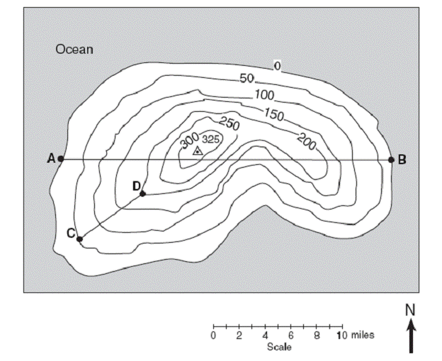
Topographic Map Review Lab Note: Remember you are responsible for graphs, charts and other items that form part of the overall summary of this topic. Vocabulary: topography - study of the shapes and features of the earth's surface elevation - height above sea level bench mark - a point that has been accurately measured for its position and elevation contour line - connects places on a map that are all at the same elevation contour line interval - the difference in elevation between neighboring contour lines Background: Historically, the development of highly accurate, detailed topographic maps has largely been driven by military requirements. A unique characteristic that distinguishes topographical maps from other kinds of maps is the fact that they show the topography or shape of the land in addition to other features such as roads, rivers, lakes, etc. Because topographical maps show the shape of the land, they are the most suitable type of map for most outdoor activities that take place in areas that are not heavily populated. Hence, in order to study landscape features, we use a topographic map. The key to using topographic maps is understanding contour lines. Each contour line connects places that have the same elevation or height. In order to understand completely the usage of topography, you need to be familiar with compass directions and map reading. Directions: Using the diagram below, answer the questions that follow.
1. What is the contour interval of this map? __________ 2. What is the highest elevation? __________ Lowest elevation? __________ 3. Measure the distance, in centimeters, from Point A to Point B. 4. Convert this distance into miles using the scale provided below the map: __________ 5. Repeat numbers 3 and 4 for Point C to Point D. cm distance: __________ miles: __________ 6. Determine the elevation at Point C: __________ and Point D: __________ Difference (D-C): __________ 7. Calculate the elevation gradient between Point C and Point D: __________ * gradient = difference in field values ÷ distance between points 8. Draw a profile that describes the elevation across line A-B. 9. Draw a profile that describes the elevation across line C-D. |